


[산업정보시스템공학] 서울 버스 정보 시스템 Bus Information System 분석 및 향후 발전 방안(영문)
 등록일 / 수정일
- 페이지 / 형식
- 자료평가
- 구매가격
- 2010.12.07 / 2019.12.24
- 19페이지 /
 docx (MS워드 2007이상)
 - 평가한 분이 없습니다. (구매금액의 3%지급)
- 1,800원
최대 20페이지까지 미리보기 서비스를 제공합니다.
자료평가하면 구매금액의 3%지급!
 1
1 2
2 3
3 4
4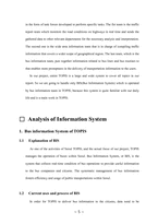 5
5 6
6 7
7 8
8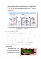 9
9 10
10 11
11 12
12 13
13 14
14 15
15 16
16 17
17 18
18 19
19
추천 연관자료
- 목차
-
Introduction 1.Background of TOPIS
1.1 Business objective of TOPIS
1.2 Business areas and functions
1.3 Business organizations
Basic analysis of Information
System 1. Bus Information System of TOPIS
1.1 Explanation of BIS
1.2 Current uses and process of BIS
2. Components of IT infrastructure
2.1 Hardware
2.2 Software
2.3 Telecommunications
3. Strength and weakness of BIS
3.1 Wireless data communication network
3.2 Integration of system
SWOT Analysis of Information System 1. Strength
2. Weakness
3. Opportunity
4. Threat
Suggestions for TOPIS 1. Technological Aspect
1.1 Campaigning on SNS
1.2 Expanding Services
2. Information Communications Aspect
2.1 Increasing Coverage through Smart Phone Applications
2.2 Disruptive Innovation for the Elderly
References
- 본문내용
-
□ Analysis of Information System
1. Bus information System of TOPIS
1.1 Explanation of BIS
As one of the activities of Seoul TOPIS, and the actual focus of our project, TOPIS manages the operation of buses within Seoul. Bus Information System, or BIS, is the system that collects real-time condition of bus operations to provide useful information to the bus companies and citizens. The systematic management of bus information fosters efficiency and usage of public transportations within Seoul.
1.2 Current uses and process of BIS
In order for TOPIS to deliver bus information to the citizens, data need to be collected. This is done through the Bus Management System (BMS). It was developed in 2005, becoming the first bus management system in Korea. The major function of BMS is the control of bus services by showing the current condition of bus operations, and the distance between the earlier and following buses to manage the time in which buses arrive at the bus stops. It does so by collecting information through the BMS servers and wireless communication including the satellite on when the bus started its course, where it is located in its course, and the arrival and departure time and name of each bus stop.
<Whole Process of BIS>
The terminal installed inside each bus transmits its GPS(Global Positioning System) location through satellites to BMS(Bus Management System). By using the GPS location, data on the location, driving speed, arrivals at bus stops are collected and transferred to the TOPIS Center through wireless communications network. The TOPIS Center processes the collected data and provides real-time bus operations information.
The data collected through BMS is then transferred to the TOPIS Center where data is processed and passed to the end users through various means. The end users include the bus drivers, manager of the TOPIS Center, relevant departments of Seoul, bus companies, and citizens. Most importantly, bus drivers are notified of the information on the time between buses and unforeseen incidents. Citizens have access to information on where the bus is located, and at what time it will arrive at the specific bus stop. The media that Seoul TOPIS uses to provide such information are BIT(Bus Information Terminal), Internet, mobile Internet (cell phone and PDA), ARS. Keeping up with the technological trend, TOPIS also provides bus information through iPhone application.
Bus information terminal refers to the terminal units placed in each bus stop that shows which bus line is how far from the bus stop, and at in how many minutes the bus will arrive. The picture on the right is a BIT that was displayed in the TOPIS Center.
Moreover, TOPIS installed larger versions of BIT inside major subway stations to facilitate the transfer from the subway to buses. The interviewee, manager of transportation information Sung-Hoon Shin, explained that the existence of terminals reduce the inconvenience of waiting for the bus outside in the cold or heat. By knowing when the bus will arrive, citizens can make better decisions. On the right is a picture taken inside the Gwanghwamoon Station (Line 5), which shows the location of nearby buses.
- 참고문헌
-
Seoul TOPIS website (http://topis.seoul.go.kr)
Seoul Traffic Broadcasting (http://tbs.seoul.kr)
Korea society of Transportation (http://kor-kst.or.kr)
Seoul mania blog (http://blog.seoul.go.kr)
Wonjae Lee(2008) – “Research for efficient operation methods for transport information and management system” (DM534.04-8-52=2 , The national library of Korea)
Euitae Jung(2009) – “A Study of a Mobile Bus Information System and Its User Interface Design Using Location-based Technology”,( Korea Design Forum Vol.23)
자료평가
-
아직 평가한 내용이 없습니다.


